Heavy rainfall expected across region on Friday
Less than a week after the end of the 2018 Atlantic Hurricane Season, a system coming in from the west is poised to give San Marcos and Central Texas a dousing.
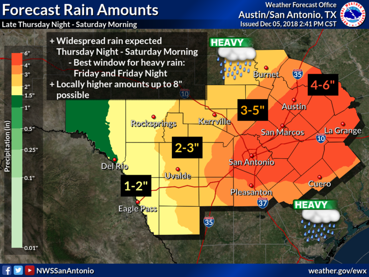
Rainfall is expected to begin tonight and intensify on Friday, delivering an estimated 4 to 6 inches in an area encompassing Interstate 35 from Austin to San Antonio. In places, forecasters say, up to 8 inches could fall, though those areas would be hard to pinpoint. The amount of expected rainfall has risen over the past 24 hours and may rise again before the weather hits.
To the west, less is expected — around one to three inches across the Western Hill Country and the Rio Grande.
In San Marcos, organizers of Sights & Sounds of Christmas are crossing their fingers that weather on Friday will allow the annual festival, which has its final run on Saturday, to take place Friday night.
“We will be closely monitoring using every resource we have,” said Tommy Curtis, president of the festival’s board of directors. “Based on history and Texas weather, we would not make the call until the day of.
The severity of weather that day would determine the timing.”
Nothing in the forecasts, as of Wednesday, had especially targeted the Guadalupe/Blanco river basin, although along the Colorado River — which saw extensive flooding in October — could be at risk.
More likely for the local area are rises in small streams, some creeks and low-water crossings. For a map of all crossings that are open or closed, visit Hays Informed.
While forecasters say the chance for rain are “very high,” the National Weather Service says the possibility for strong storms is low.
“If any severe storms develop, damaging straight-line winds and a small tornado threat would be impacts across southeastern counties Friday afternoon and evening, the service said. “The Storm Prediction Center has placed this area in a Marginal risk for severe storms.”
The system is expected to move out of the local area Saturday evening, but temperatures are expected to turn colder, with an overnight low Saturday of 38 and on Sunday night, 34.