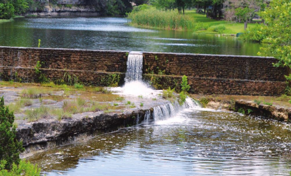
The water of Lone Man Creek in Wimberley flows strongly over a dam near the crossing over FM 3237. This has helped the spring flow in the Wimberley Valley, but the Trinity Aquifer still needs more rain to recharge. Wimberley View photo by Dalton Sweat
Rain helps spring flow, aquifers still low
A welcome month of rain has filled the creeks and lifted the burn ban after going the better part of a year without substantial rainfall. As needed as the rain was, it still has barely put a dent in the historically low aquifer levels that are impacting the Wimberley Valley.
“The rain has been so beneficial for the trees and plants and wildlife; the creeks and streams are flowing,” Charlie Flatten, General Manager of the Hays Trinity Groundwater Conservation District, said. “But we need a lot more rain.”
There are multiple different measures of a drought, many of which look quite promising given the fact that it is close to the summer season.
The Keetch Brauman Drought Index measures the amount of moisture in the soil. It is used to estimate the risk of wildfires. Hays County uses it to help inform when the burn ban may need to be put in place or removed.
As of this week, the majority of the state of Texas, with the exception of far West Texas, is in the lowest range of the drought index as a result of the recent rains.
Hays County has an average KBDI of 39 right now. On a scale of 0 to 800, where zero is the lowest chance of wildfires and 800 represents “absolutely dry conditions,” it is a great place to start summer from.
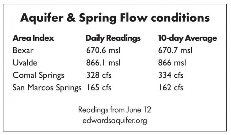
When considering whether or not to go into drought restrictions, the Hays Trinity Groundwater Conservation District uses multiple factors, one of which includes the flow of Jacob’s Well and the Blanco River.
“Spring flow has responded,” Robin Gary, Managing Director of the Wimberley Valley Watershed Association, said. “We saw a sharp increase after the rain events, but they are returning back to their normal base flow conditions and that is higher than it was before. That means water got into the system.”
Jacob’s Well flowed at less than three cubic feet per second for the entire month of March and dipped to lows that neared zero. This week, it is sitting back in the double digits with spring flow ranging from around 10 cubic feet per second to a little over 20 cubic feet per second.
The Blanco River tells a similar story. Through March it was a little over 3.5 feet deep at the gauge at the Ranch Road 12 bridge. The flow of the river was between 15 and
20 cubic feet per second. This week, the depth of the river was closer to 4.25 or even 4.5 feet at the gauge and flows were as high as 155 cubic feet per second and as low as 110.
Those are two indicators that the aquifer may be ready to rise, but so far that has only started to occur.
“We need a lot more rain,” Flatten said. “Thankfully, Jacob’s Well has responded… That rebounded a little bit quicker and that is great news. We are seeing improved flows out of that. You can be comforted by that, but it’s a slow process. We need more than eight inches of rain, and we need it spaced over time. We needed this rain but we sure do need more.”
The monitor wells in the Wimberley area have shown the slightest increase in aquifer level, but the level is still in the range of the lowest ever recorded.
The Mount Baldy well, which is used by the Wimberley Water Supply Corporation, has data reaching back to late 2005. This period includes both the severe drought in 2011 and the floods in 2015. The highest the water level has been in that well in that time frame was in 2006 just after it was first installed. The water level nearly reached 90 feet below land surface. Between 2006 and 2019, the lowest level it reached was around 139 feet below land surface in late 2011.
In late 2020, that water level fell to its lowest point around 148 feet below land surface. After a brief rise, it fell again to a new record low of almost 150 feet below land surface in March of 2021. The rains have leveled off the declines and perhaps even started to turn the water level the right direction.
“Once the soils are saturated, any rainfall that hits the ground runs off,” Gary said. “That is where we are right now. The soils are saturated and they allow run off. That means the recharge creeks can funnel water into the aquifer system.
“...Right now the conditions are ripe to allow more recharge, so each inch of rain will really produce optimal recharge, and we need more rain to replenish the groundwater supplies that would sustain spring flow through the summer and sustain river flows. Base flows (in creeks and rivers) are reliant on groundwater, and so are wells that provide water for well owners too.”
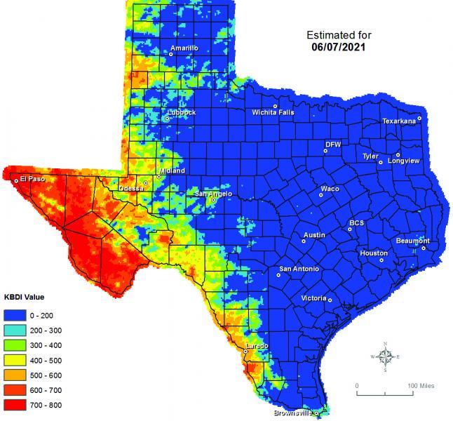
Above, a map shows the Keetch Brauman Drought Index measures the amount of moisture in the soil. Hays County uses it to help inform when the burn ban may need to be put in place or removed The map shows that most of Texas is currently at a low KBDI, meaning there's a lower chance of a wildfire. Further west, KBDI levels increase. Infographic via Wimberley View
“We need a lot more rain. Thankfully, Jacob’s Well has responded… That rebounded a little bit quicker and that is great news. We are seeing improved flows out of that. You can be comforted by that, but it’s a slow process.” — Charlie Flatten, Hays Trinity Groundwater Conservation District General Manager