The first severe weather chance of 2020 is expected Friday, according to the National Weather Service.
NWS Austin/San Antonio Meteorologist Bob Fogarty said a cold front will arrive Friday afternoon with storms lining up in front of the system.
“There’s a cold front which is moving toward the area (Friday, Friday night,),” Fogarty said. “Ahead of the cold front, we’re in this southerly, southeasterly flow, so we have a lot of warm moist air that’s moving in from the Gulf right now and that’s going to be in place before the front comes through. When the front comes through, we think it’ll generate thunderstorms and because of all the warm, moist air and the colder air aloft that’s coming in with the front, it’s a situation where some of those storms could get to be strong to severe.”
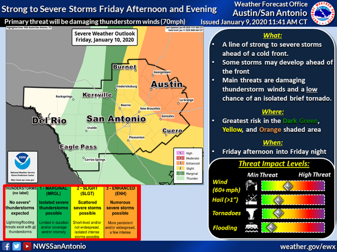
The weather service has put San Marcos in the slight risk range for strong weather Friday, meaning there’s a chance for scattered thunderstorms throughout the afternoon into the evening. Northern Hays County, however, has been put in the enhanced risk area, which increases the chance for numerous thunderstorms in the area.
According to the NWS, the area of concern is along and east of Highway 281 with the greatest threat being east of Florence to Austin to Luling. The weather threat is expected to bring damaging thunderstorms with high winds and the chance of an isolated tornado and large hail.
“(The storms are) going to develop here and then move to the east,” Fogarty said. “San Marcos is in the slight risk area and then a little bit closer to the north and to east is the enhanced area. The Ingredients look a little better (north of San Marcos) than they do down toward San Marcos. At this point, the most likely impacts from these storms, we think the most likely thing would be damaging wind gusts possibly as high as 70 mph and there is a chance of isolated tornadoes as the front comes through. There’s some risk of hail but it’s probably the least possible of the three.”
With the first threat of dangerous weather of the year, Fogarty said being aware of the forecast and warnings will be important.
“It’s been quite a while since we’ve had anything like this so people should just be aware that the weather could get bad (Friday),” Fogarty said. “There’s also the threat of lightning and thunderstorms. So, be prepared for lightning and strong winds. There’s the possibility of a tornado. If you have tornado warning make sure you know where to go and what to do.”


