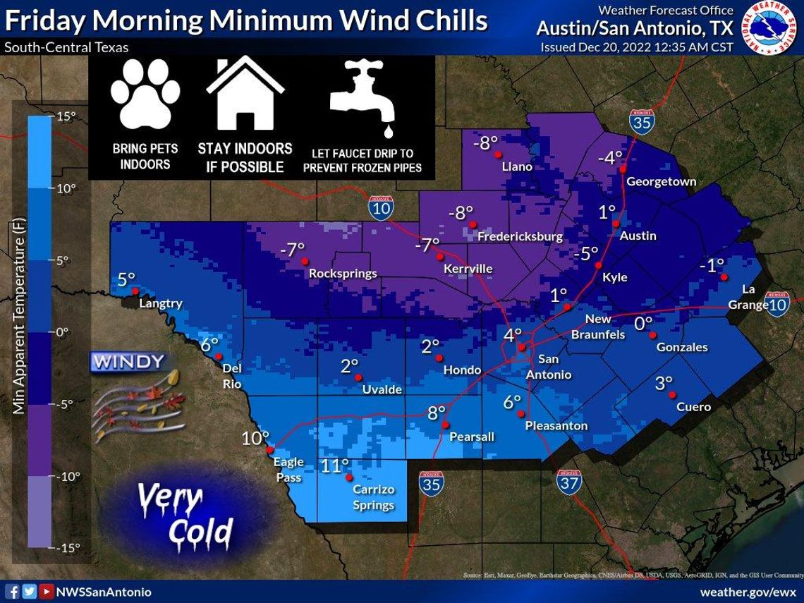
A strong, Arctic cold front will blow through San Marcos on Thursday, bringing with it wind chills near or below zero degrees Friday morning.
The National Weather Service has issued a wind chill watch, which goes into effect Thursday at 6 p.m. and lasts until noon on Friday. A hard freeze watch will go into effect Thursday at noon and stretches until Saturday at noon.
“In the wake of that cold front will be very, very cold Canadian air that will begin filtering into the region quite rapidly,” NWS Meteorologist Andrew Quigley said. “We’ll probably see 20-25-degree temperature drops behind that front relative to what we warm up to Thursday afternoon when it gets here. Combined with that very cold air, we’re going to have very breezy, even windy conditions across the entire area from Thursday night through early Friday morning. That combination of very cold Canadian air combined with the gusty winds is going to lead to downright frigid air temperatures but also wind chills from late Thursday night into Friday morning.”
Quigley said the cold front is expected to arrive in the San Marcos area between 12-4 p.m. on Thursday. The National Weather Service forecasts highs on Thursday to reach 59 degrees before plummeting to 16 degrees overnight into Friday Morning.
Quigley said gusty winds will drop wind chills to near zero or below zero Friday morning. High temperatures will be near freezing or just above Friday afternoon. Overnight temperatures Saturday will fall into the upper teens. The high temperatures in San Marcos are expected to reach 40 degrees Saturday.
Precipitation is not in the forecast with this cold front.
“Though, we will still see very cold temperatures begin to settle in behind that front,” Quigley said. “The other big thing that’s going to contribute to all this is the gusty winds in the 20-25 mph range, the way things look right now, which will contribute to very frigid wind chills near or just below zero on Friday morning. Those two things pieced together — the extended cold through Saturday and the frigid wind chills through Friday morning — have led us to issuing two products for cold weather, one of which is a wind chill watch through the entirety of south Central Texas, including San Marcos … Additionally, the extended stretch of cold temperatures is going to be very harmful to any sort of outdoor plants, so we have also issued a hard freeze watch.”
NWS recommends bringing pets indoors, staying indoors if possible and letting faucets drip to prevent frozen pipes.


