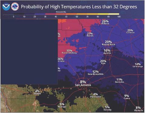
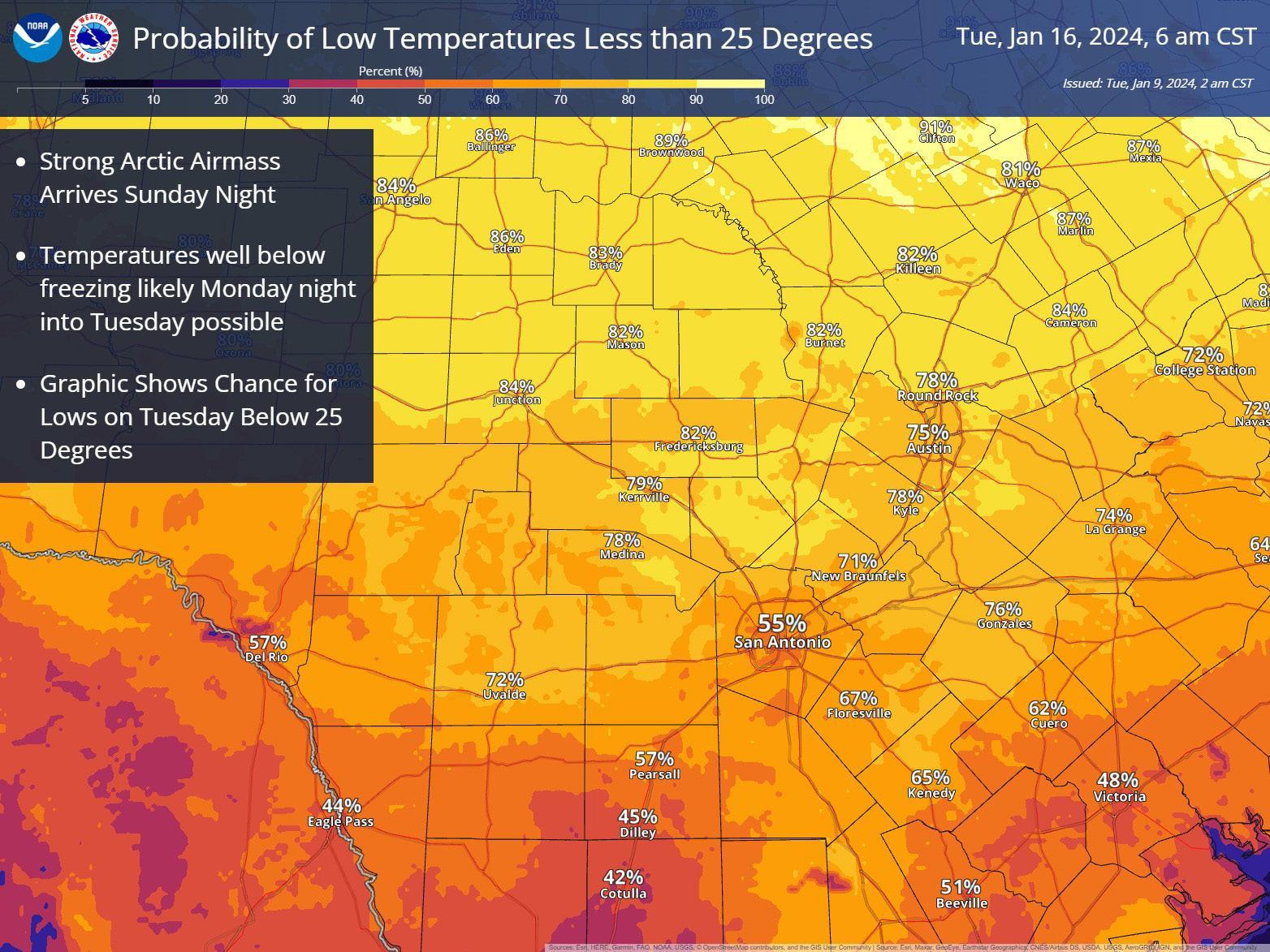
The National Weather Service Austin/San Antonio is predicting that a cold front will come into the area on Sunday. With that cold front “there is a 20-30% chance that highs Monday could stay below freezing and high probabilities that lows Tuesday morning will be below 25 degrees for much of the area.”
Graphic provided by the National Weather Service
Winter is Coming
Day-long freeze possible next week
Winter is on its way to Central Texas as the National Weather Service expects the strongest cold front of the season to bring freezing temperatures starting as soon as Sunday night.
“We are going to get a very strong and cold front through South Central Texas,” Bob Fogarty, a meteorologist for the National Weather Service Austin-San Antonio said. “It will probably be the coldest temperatures of the season so far.”
In the San Marcos area, they are expecting the temperatures to be around 25 degrees on Sunday night to Monday morning with a hopeful high of 40 degrees before dropping to as low was 15 degrees over night heading into Tuesday.
“And we could see some wind chill temperatures that dip into the single digits,” Fogarty said. “Maybe five degrees or even lower for Tuesday morning. That looks like it would be the worst of it.”
Right now, that cold snap looks like it won’t have any precipitation, but that may change.
“It doesn’t look like there will be, although some of our models are starting to suggest that there could be a short duration of winter weather probably Sunday night or early Monday,” Fogarty said. “Right now, we don’t have anything mentioned in the forecast, but it’s something that people should keep an eye on as we get closer. It’s still a long ways off. Our forecast can change over that time period. It could go either way. It really could get worse. It could get a little better. So, people should be paying attention, particularly over the weekend.”
Beyond the possibility that there could be precipitation, there is also a
•Strong Arctic Airmass
Arrives Sunday Night
• Temperatures well below freezing likely
Monday night into
Tuesday possible
• Graphic Shows
Chance for Highs on
Monday Below Freezing chance that areas around Hays County and further northwest could stay under freezing for the entire day on Monday.
“That is probably not in the San Marcos area,” Fogarty said. “That is probably more in the colder areas up in the Hill Country and out in the Edward’s Plateau. There is probably less than a 20% chance that the temperature that far south (in San Marcos) stays below freezing. There is a possibility, but … out in the western part of Hays County, yeah, I think there would be some concern. Especially colder spots, which tend to be the sort of valleys and places. That’s where the cold air settles. So out in the hillier parts of the county, I think there is a possibility that they could stay below freezing.”
Make sure to plan for the four “Ps,” of people, pets, plants and pipes.
Take steps now to protect tender plants from the cold. To prevent freezing and possible bursting of outdoor water pipes they should be wrapped, drained, or allowed to drip slowly. Those that have in-ground sprinkler systems should drain them and cover aboveground pipes to protect them from freezing.